Heeled Waterlines
by Reinhard Siegel
Method 1 - model sy15-b.ms2
The most simplest attempt is demonstrated in model sy15.ms2. The hull surface hull on the starboard side has its counterpart on the portside in the Mirrored Surface hull_ps. Its Mirror support entity is the system entity *Y=0.
Both surfaces are cut by the Contour heeled_wl, which uses the 2-point Plane plane1 as Surface/mirror support. The supports for this plane are the Points pt1 and pt2. The Coordinates property of pt2 is set to Polar, so changing its Latitude value heels the plane. Sink is controled by the Z-coordinate of pt1.
Use View/ Modify/ Set View/ Normal to... to look perpendicular to the waterplane plane1. Export as DXF via File/ Export 2D (exports the screen view). This methode is fine for a quick picture of the situation.
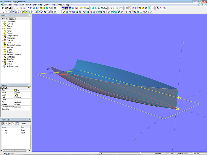
Model sy15-b.ms2 – waterlines at heel
Method 2 - model sy15-heeled_dwl.ms2
While in the previous model just a raw picture of the situation under heel is available, model sy15_heeled_dwl.ms2 provides accurate geometry. Basis are the hull surface hull and the Roll_Pitch_Yaw Frame frame1 (RPY Frame). Origin of frame1 is the point sink.
Into this frame the starboard side and the portside of the hull surface are copied as Copy Surfaces hull_stb and hull_ps. Please note, that for the portside copy just the property “y-scale” of the Copy Surface entity needs to be set to -1.
In order to get the intersection of the water surface with the heeled boat, those 2 Copy Surfaces hull_stb and hull_ps are cut by the Contour wl using *Z = 0 as Mirror/surface.
Now, when you know from Hydro the free floating position of the boat on the water, note the values for Sink, Heel and Trim and enter these in the model (the Z-coordinate of Point sink gets the Sink value, the RPY Frame frame1 gets the data for heel and trim.). Export via Ship Lines of File/ Export 2D.
Model sy15_heeled_dwl.ms2 –free floating waterline at heel
Method 3 - model Hydro_free_floating.ms2
In the Tutorial #14 there is the chapter “Advanced Application of Variables and Formulas”. Here the use of the Hydro function inside MultiSurf is discussed. The model Hydro_free_floating.ms2 shows how to combine that function with the Solve feature to find the balanced floatation at heel for a given mass and center of gravity.
This method avoids the detour to Hydro.
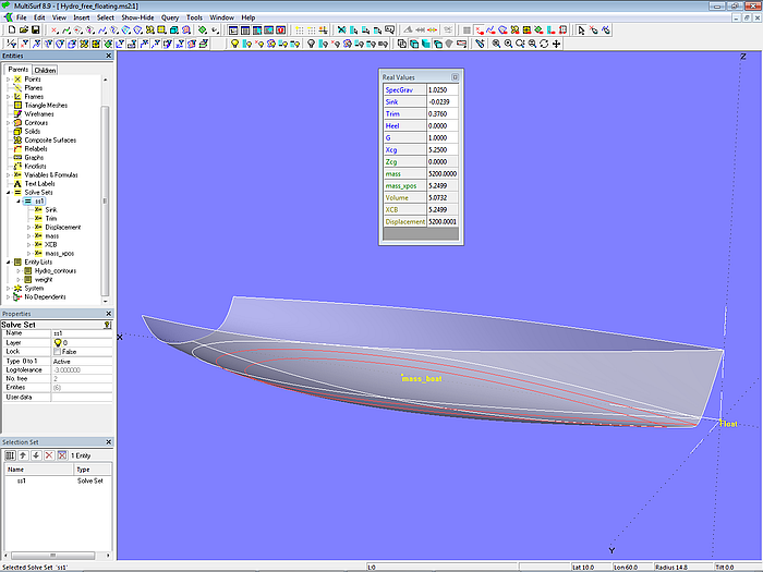
Model Hydro_free_floating.ms2 –free floating waterline at heel
Critical points
Methods 2 and 3 allow to define critical points directly in the MultiSurf model. Thus the distance to the waterplane is known. Their mapping in any other coordinate system (frame) is easily done then.
======================================================================================